
© 2023 by the authors. Published by Michelangelo-scholar Publishing Ltd.
This article is published under the Creative Commons Attribution-NonCommercial-NoDerivs 4.0 International (CC BY-NC-ND, version 4.0) license (https://creativecommons.org/licenses/by-nc-nd/4.0/), which permits non-commercial use, distribution, and reproduction in any medium, provided the original work is properly cited and not modified in any way.
Share and Cite
Chicago/Turabian Style
Yixiong Hua, and Song Qiu, "Review of Urban Cultural Map Research Based on ‘Mapping’." JDSSI 1, no.2 (2023): 27-38.
AMA Style
Yixiong Hua, and Song Qiu. Review of Urban Cultural Map Research Based on “Mapping”. JDSSI. 2023; 1(2): 27-38.
References
1. Ling Huang, Wanmin Zhao, and Jianfeng Xu, “Urban Cultural Map and Urban Cultural Planning,” Planner, no.8 (2008): 67-71. [cnki]
2. Qilong Zhao, “Cultural Construction of Urban Open Space from the Perspective of Mapping” (M.A. thesis, Dalian University of Technology, 2021). [cnki]
3. Huixi Li, “Theoretical Research on Landscape Architecture Based on Mapping” (Ph.D. thesis, Southeast University, 2017). [cnki]
4. Xi Zhu, “Analysis of Cultural Maps,” Urban Survey, no.3 (2021): 126-129. [cnki]
5. Lynch K A., The Image of the City (Cambridge MIT Press, 1962).
6. Lynch K A., A Theory of Good City Form (Cambridge MIT Press, 1982).
7. Daniele Balicco, “Fredric Jameson, Postmodernism, or the Cultural Logic of Late Capitalism, 1991,” Allegoria 56, (2007): 201-212. [Google Scholar]
8. Henri Lefebvre, The Production of Space (Oxford: Blackwell Publishers, 1991).
9. Xuanyang Gao, Foucault’s Aesthetics of Existence (Beijing: China Renmin University Press, 2005).
10. Qin Gao, “Exploration of Contemporary Mapping Thought” (M.A. thesis, Southeast University, 2010).
11. Xi Yang, “Conceptual Transformation in Heritage Conservation Book Review of Cultural Mapping: A Guide to Understand Place, Community and Continuity,” Time + Architecture, no.3(2021): 151-153. [cnki]
12. Zuqun Zhang, and Bo Wang, “On the basic approach to drawing a city's cultural map,” Urban Management and Science & Technology 15, no.3 (2013): 27-29. [cnki]
Preliminary Research
Jean Gottmann, Director of the Department of Geography at Oxford University (1915-1994), proposed the concept of megalopolis. Henri Lefebwre (1901-1991), an outstanding French thinker and founder of Marxism, as well as Milton Friedman (1912-2006), a contemporary American economist and a scholar at the University of Chicago, both used the term “urban field” to explain the local patchwork and multicenter urban form. American geographer Edward W Soja (1940-2015) created the concept of an “exopolis” and referred to today’s urban form as a “post metropolis.” Deyan Sudjic (1952-), an architectural art critic and visiting professor at the Royal College of Arts in the UK, described a vast and constantly expanding city as a “100-mile city.” It should be said that the second half of the 20th century was the era of the peak of architectural theory, during which theoretical research related to mapping included Kevin Lynch’s “invisible city,” Lefebvre’s urban theory and daily life mapping, Manuel Castells (1942-) megacity, Michel Foucault’s (1926-1984) spatial power map and Giles Deleuze’s (1925-1995) concept of “rhizome” and “generative” coherence plane, among others. The emergence of these diverse spatial studies and mapping concepts not only characterizes the drastic changes in contemporary urban spatial form and structure but also expresses people’s strong desire to reunderstand and accurately capture contemporary urban spatial form.
In the 1960s, Lynch first proposed “cognitive mapping” to understand the concept of “intangible cities” and thus opened a new scientific connection between cities and human behavior. Its environmental representation theory based on human geography and behavioral psychology has been adopted in the field of architectural space. At the same time, Lynch’s two works, The Image of the City (1960) [5] and A Theory of Good City Form (1981) [6], improved the concept of “cognitive map” while also giving birth to a sub discipline. A subsequent sociologist, Frederick Jameson (1934-), was influenced by Lynch’s research. In 1984, he published the paper Postmodernism or the Cultural Logic of Late Capitalism, which was the first time that the concept of cognitive map was cited, and his ideas were summarized in two sections titled “The Need for Maps” and “The Symbolism of Social Mapping.” In 1988, Jameson wrote another article called Mapping of Cognition, which once again discussed this theoretical idea, indicating his attention and continuous exploration of this topic. In the discourse of social space, the concept of mapping is introduced, and it is noted that reflecting on social space is based on the unique geographical and cartographic state of things.
Jameson proposed the political potential and educational value of maps from the perspective of space in modern society. In his view, mapping is a tool for perceiving and recognizing space, a supplement to Lynch’s cognitive mapping theory. He ultimately stated that cognitive mapping “should provide the subject with a rational reproduction of this endless and virtually impossible entire urban structure [7].” It is clear that Jameson’s “cognitive map” idea was not only inspired by Lynch but also an urgent need for practical social dilemmas and research development. Afterward, he also focused on the issue of planarity in the postmodern “Symbolization of Social Drawing.” This planar relationship can be linked to Deleuze’s philosophical concepts of “pleats” (褶子) and “solution domains” (解域). The concepts of “solution Domain,” “territorialization” (辖域化), and “reterritorialization” (再辖域化) were invented by Deleuze. Each “solution domain,” “territorialization,” and “reterritorialization” constitutes the mapping of routes, which is the drawing of maps. It can be said that Deleuze and Jameson have rearranged our perspective on observing the world and created a new cognitive map for viewing this flowing world.
It is generally believed that the stories of postmodern spatial mapping originating from the humanities came from Lefebvre and Foucault. Their research on cities and architecture has influenced many scholars, including Baudrillard, David Harvey (1935-), Edward W Saja, and Manuel Castells in their theories of space and society. Lefebvre emphasized attention to daily life. In his book “The Production of Space” published in 1974, he proposed the concept of “social space,” explaining the dialectical and unified relationship between social space and social production. Therefore, he proposed viewing vivid and free forms of daily life as the greatest hope for urban sustainability and development [8]. His praise of ordinary things and criticism of the commodified daily life of manipulated life constitute his mapping of urban social space. On the other hand, Foucault weaves a network of urban spaces manipulated by power. Invisible power is the core issue in Foucault’s research on social space [9]. By examining the corresponding relationship between space and embodied power, Foucault completed the construction of a dynamic topological map of contemporary cities and social spaces.
In Beyond Projection: A Study of Architectural Graphics from a Cultural Perspective, Dr. Wu Cong from Tianjin University systematically discusses the development and differences of architectural graphics between China and the West. The emphasis is placed on the different architectural drawing methods caused by spatial concepts in different cultural and social backgrounds, with a focus on the sorting and comparative study of different drawing methods in the East and West.
In recent years, there has been relatively more research on the hot topic of Western architectural theory - “illustration” in China. The most famous architectural schools in China have published master’s or doctoral theses on illustration in recent years; however, the research on mapping is still in its infancy, and most of it is still at the level of conceptual exploration. The master’s thesis Exploration of Contemporary Mapping Thought by Gao Qin from Southeast University is a relatively complete master’s thesis on the theme of mapping, mainly elaborating on the practical achievements and important roles of mapping in contemporary architecture, art design, and cultural fields [10]. Due to the focus on describing and analyzing the concept and specific operations of mapping, there is not much historical research on its revival and development in architecture. In addition, James Connor’s The Power of Mapping: Reflection, Criticism, and Innovation translated by Professor Li Pang of Southeast University played a very positive role in the author’s thesis’s conception, research development, and conclusion formation. It is situated within the rich background of multiple disciplines, such as philosophy, physics, contemporary art, social theory, geography, and political economy. In addition, the careful and cautious translation of the author’s paper by Teacher Li Pang have had a profound impact on and provided multidimensional guidance for the author’s writing.
The search results using the keyword “mapping” show that Dr. Duan Wei’s Prototype Strategy, Dr. Liang Shuhua from Huazhong University of Science and Technology’s Hanzheng Street Map Analysis, and Dr. Zhang Jun’s Research on Urban Ecological Unit Mapping and Protection Planning Based on GIS and RS all have certain intersections. Although they do not match the title of this topic, from the perspective of map analysis and GIS application analysis, there is a certain intersection between them. However, there is some overlap in research content mapping analysis and the application analysis of geographic information systems, which also indicates that although the starting points for exploring may be different in contemporary architecture research, the research on mapping, illustration, and analysis in planning and landscape disciplines has begun to deepen in China. On Symbolic Design in Environmental Regulation Art is a study by Yang Zhihua from Hunan University that broadens his research perspective from multiple aspects such as imagery, phenomena, symbols, archaeology, etc. In addition, Li Han proposed Research on the Form and Layout of Urban Open Space in Western Countries from the Perspective of Landscape Urbanism also provides some empirical support for the above issues. On the other hand, China’s research on architectural visualization has provided some good ideas for the relationship between mapping and urban cultural maps. For example, Liu Lun’s article Exploring Contemporary Urban Spatial Awareness through Visualization at Nanjing University provides an introductory analysis and sorting of contemporary urban spatial cognitive visualization methods. The doctoral thesis of Han Xiaofeng from Southeast University, titled Understanding, Interpreting, Operating, and Illustrated Methods of Contemporary Urban Architecture, systematically summarizes the classification, characteristics, and application potential of various graphic methods in contemporary urban architecture cognition and design.
Review of Urban Cultural Map Research Based on “Mapping”
Introduction
Against the background of China’s implementation of a high-quality development strategy, urban development has entered a new era of cultural feedback. Based on its own characteristics, improving cultural soft power, enhancing cultural confidence, and depicting cultural landscapes have become the main ways to improve urban competitiveness. In recent years, with the introduction of the concept of “urban cultural map,” China has conducted in-depth research on and achieved fruitful research results. In developed countries such as Europe and the United States, the concept of “city culture maps” is widely used. These maps are mainly implemented via the internet as a vehicle to obtain pictures and information related to historical and cultural locations and events to facilitate users’ searches and access to relevant information. For example, some artist internet websites, under the banner of “cultural map,” enable searching for art works in only specific locations. Urban cultural maps are important carriers of regional characteristics, enabling urban culture to be inherited and promoting the spirit of the place. They have high value in science, education, culture, history, art, and other domains.
The cultural quality of cities is reflected not only by their historical and cultural heritage but also through new cultural changes, which can be vividly displayed in specific urban spaces. Culture consists of two parts: material and intangible. Whether a city’s historical and cultural heritage is well protected is closely related to its people’s values, cultural literacy, and the level of economic development. In numerous urban planning practices and studies, we have found that constructing urban cultural maps and promoting and serving urban cultural development from the perspective of informatics can have a positive impact on the cultural planning and construction of urban space and can dynamically reflect and promote the process of urban civilization. On this basis, we need to pay attention to and strengthen the research on urban cultural maps in the fields of urban planning, architecture, and landscape design, as well as in the cultural and tourism fields, to promote their widespread application and gradually move toward maturity.
Mapping is not only a surveying technique in cartography but also a traditional method of describing the current situation. It is also a means of interpreting and constructing landscape models. James Connor sees it as an effective method of collecting, describing, and analyzing information from human life, uncovering its potential and unknown value. Its main purpose is to break through existing material and spiritual limitations and gradually reveal the hidden structure. Mapping provides not only a true reflection of the real world but also a powerful means of transforming the human living environment. This is an innovative and revolutionary analysis method [1]. Maps are objective descriptions of real information, while mapping is the subjective analysis of people that organized this information through a systematic process. It is precisely through the process of cognition, judgment, and reproduction that the enormous potential value of “mapping” for urban architecture and landscape is revealed.
Culture is a very important issue in the study of urban maps. Given current urban issues, how can we re-explore the construction of new urban culture and, on this basis, explore new methods and models of urban design, which requires new research perspectives and construction strategies [2]. The “urban cultural map” generated to map the urban open space of urban culture is the starting point of this paper for research on and construction of relevant theories. On this basis, this article attempts to explore new possibilities for urban development from the perspective of mapping and the correlation between urban cultural maps.
Concept Explanation
Mapping
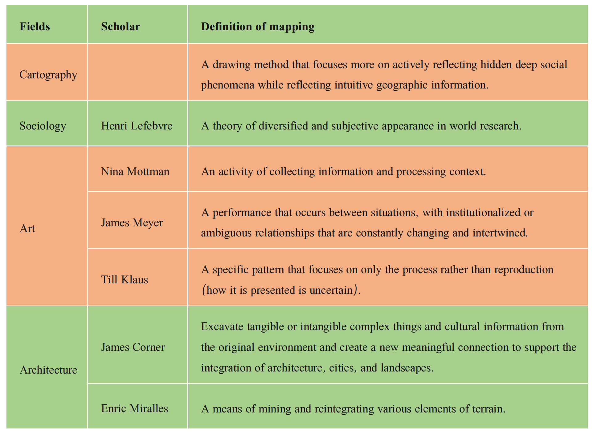
The concept of “mapping” in this study follows the discussion of scholar Li Pang in The Power of Mapping and translates the word “mapping” into Chinese. However, this concept is easily confused with the concept of “mapping methods” on the surface in Chinese, so it is necessary to distinguish the concept of “cartography” in geography, which are the steps of map drawing in geography, from “mapping,” which tends to be more inclined toward the entire map cognition-analysis-expression process. On the other hand, mapping also involves representation, emphasizing its process. Mapping is the process of plotting the material world and associating it with conceptual diagrams [2]. Tracing the generation and development process of maps reveals that mapping does not exist independently but is closely related to traditional disciplines such as geography, surveying, planning, mathematics, and even aesthetics. In a simple summary, mapping is a science developed from cartography and draws on multiple disciplines for its development. It aims to intuitively reflect geographic information and pays more attention to actively reflecting hidden deep social phenomena and deriving coping strategies by observing and recording the surrounding environment. Mapping is a bottom-up approach (Table 1).
In the field of architecture, scholars generally claim that mapping is a graphical design practice based on maps and cartography [2]. With the development of the discipline and a deepening of understanding, mapping has transformed from a traditional tool in form to a creative and ingenious cognitive media and design thinking method [3].
Abstract
Urban cultural maps are important analytical tools that can guide urban design and planning from the perspective of information, provide services for urban cultural development, promote cultural planning and the construction of urban space, and reflect and promote the process of urban cultural progress in a dynamic way. Mapping is often used as a process tool for mapping, cognition, and analysis in geography or surveying and has recently been applied in architectural science. The field of architecture has given mapping a new definition and played a certain role in urban research and development. This article introduces the concepts of mapping and urban cultural maps, as well as the relationship between them. Through a review of theoretical research and relevant practices, it provides new perspectives and possibilities for urban development.
Conclusion
The research of this paper is mainly based on the background of Western cartography theory and Western spatial information mapping practice. However, studying Western theories aims to provide a reference and inspiration for China’s own mapping development and exploration. Although the theory of mapping has been discussed for less than twenty years, there has been a trend of interdisciplinary research. At the same time, there is a wealth of research data and achievements on various topics. Comparatively speaking, research on mapping in China’s architectural community is just beginning. Although there are also some research achievements in mapping in the fields of earth science, cartography, and geography, there have been few studies in China’s architectural discipline that draw on and apply the research experience of mapping in these fields. Therefore, this article hopes to contribute to the development of relevant research. We firmly believe that the logic of architecture depends on the texture of the city and the reasonable dependence of space on respect for the place. In the future, mapping should be applied to urban analysis and design more widely, such as by combining artificial intelligence and big data to organize information and establishing systems using technologies such as WebGis.
Table of Contents
- Abstract
- Introduction
- Concept Explanation
- Preliminary research
- Design Practice Application
- Conclusion
- Conflicts of Interest
- References
Yixiong Hua,
by
Suzhou University of Science and Technology, Suzhou, China
* Author to whom correspondence should be addressed.
JDSSI. 2023, 1(2), 27-38; https://doi.org/10.59528/ms.jdssi2023.1009a8
Received: September 2, 2023 | Accepted: September 30, 2023 | Published: October 9, 2023
Urban cultural map platforms are being constructed in other cities, such as Taipei, Washington, and Rome. The emergence of this platform has brought about a revolutionary change in people’s understanding of cities, culture, and the future. It is a product of the combination of modern science, technology and traditional culture. The application value and broad prospects of urban cultural maps can be seen from the work of drawing urban cultural topographic maps in many cities outside China.
Comparing urban cultural maps from different periods can reveal the changes in urban culture, as well as the growth and disappearance of cultural species, individuals, and populations, which enables the analysis of the reasons for their occurrence and identify the laws and lessons learned. When a city has suffered a cultural disaster, the loss of its cultural heritage and the rupture of its cultural layer are both tragic results. For example, after experiencing several social changes in modern times, the initial functions of buildings in historical neighborhoods and the lifestyles they rely on have undergone significant changes in the past forty years of economic development or have been completely replaced. Buildings that originally served as office building have been converted into residential buildings. Original residential buildings and their alleys, apartments, and garden houses have undergone significant changes in their types of residents, which has led to continuous changes in the culture carried by historical buildings. For example, Yuyuan (愚园) Road used to be inhabited by celebrities from various sectors of society, but now the residents have become a new mixed social class with a lifestyle that is greatly different from those of previous residents. This change can be recorded through the results of cultural mapping, cultural maps, which can also visualize intangible information such as public activities in cities. By examining the positive and negative attributes of urban public space, the causes can be analyzed, providing a basis for the transition of urban public space from negative to positive.
Horizontal cultural comparison shows that cities differ in their cultural characteristics, cultural diversity, cultural inclusiveness, and cultural and historical connotations. Introducing the indicators of surface density (number of cultural units per unit area) and linear density (number of cultural units per unit length of a spatial route) of urban cultural units allows comparing the richness of urban culture. The historical value accumulated by different cities reflects the cultural heritage they possess. One of the main reasons for this gap in historical value is that many historical towns often neglect the material preservation of regional, ethnic, historical and cultural deposits during the construction process. For example, in the late 1980s, with the acceleration of urbanization, many distinctive residential buildings and neighborhoods in the ancient city of Tianshui (天水) were demolished, causing irreparable damage and reflecting the cultural and ideological issues at that time. Of course, the creation of new cultural spaces is a cultural innovation for contemporary people. If a city can retain the radiance of ancient times when dealing with historical and modern values, it can better reflect the cultural literacy and compatibility that the city possesses.
Conflicts of Interest
The authors have no conflicts of interest with respect to the research, authorship, or publication of this article.
Design Practice Application
In the book Measuring the Landscape of America coauthored by Kona and Alex S. Maclean, a combination of aerial photography and multilayer topographic maps showcases the landscape of the United States under large-scale industrial production and consumption patterns. Kona recorded the “machine city” under industrial and agricultural regulations and the state of natural ecosystems on a large scale through mapping in the United States. This design involves a bottom-up process that focuses on mining tangible or intangible information about complex things and culture while also laying a firm foundation for the integration of architecture, city, and landscape.
Planner Mirales used mapping in urban design to express the design plan and map in a fuzzy overlay. His design plan is based on imitating and reconstructing natural terrain, finding inspiration and elements from the terrain, and combining the design site with the base terrain. In his view, mapping is a method of mining and restructuring various elements of terrain. He combines elements such as historical culture, natural terrain, and urban streets into an abstract design grid, overlaying natural terrain with an imaginary artificial base to create a special flat form.
The Role of Participatory Cultural Mapping in Promoting Intercultural Dialog “We are not hyenas” A Reflection Paper published by UNESCO in 2009 focuses on the important role of cultural mapping in heterogeneous cultural exchange. In the same year, the organization published the Building Critical Awareness of Cultural Mapping - A Workshop Facility Guide, which emphasized critical thinking about this tool and pointed out that it can enable the voices of the strong and the weak to be expressed and recognized simultaneously and plays a positive role in various basic United Nations tasks, such as intergenerational transmission of knowledge and gender equality. However, the risks associated with ethics, participation in group selection, and trust of the local people should also be taken seriously. This only briefly introduces the implementation method of the workshop. For example, in the Cultural Mapping Toolkit published by the Canadian heritage agency Legacies Now and Creative City Network of Canada in 2010, the article provides a detailed explanation of the implementation process of cultural mapping [11], which involves the determination of goals and frameworks, the design of survey and interview questions, the selection of result forms, and determining methods of publication. However, there is a lack of systematic operational steps and application examples.
At the same time, practical cases continue to emerge around the world, involving cultural resource management of heritage sites, intangible cultural heritage protection, etc., and these are addressed mainly in the form of workshops and research, with some results published. For example, in Africa, UNESCO collaborated with the nonprofit organization Protection et Revalorisation des Cultures enVole de Disparition to organize a workshop documenting and protecting the cultural resources of the Pygmies in Gabon to gain a clearer understanding of their traditional way of life and provide a platform for stakeholders to explore development policies. In the Asia Pacific region, the UNESCO Jakarta office published the Borobudur Cultural Mapping Report and Artisan Baseline Survey in 2014. This report is a survey of Indonesian handicrafts, recording data on handicrafts and craftsmen from many rural areas, mainly including the source of raw materials and unit production time. The price and packaging method are also related to the education level, age, ways to learn skills, and willingness to impart and improve the skills of craftsmen, but there is no theoretical explanation for cultural mapping.
Taking Shanghai as the research object, the main functions of the Shanghai Cultural Map Online Service Platform are to integrate the cultural information resources of Shanghai, serve public management needs, and provide experiential services for local residents and tourists. The Shanghai Urban Cultural and Historical Map presents the former residences of celebrities, excellent buildings, various factories, and locations of major historical events that occurred in Shanghai from the establishment of the settlement until 1978, reproducing the profound cultural heritage and characteristics of Shanghai through text instructions, old and new images, computer touch screen, etc., to assist with reading the map [12]. By using GIS technology, the historical evolution process, diverse and unique regional development process, and the social and cultural development trajectory refracted from this in Shanghai are transformed into a continuous and dynamic landscape historical map form and comprehensively, scientifically, and systematically displayed. This image is based on the design and construction of the Shanghai Urban Historical Landscape Database. The database is supported by ACCESS software, and the key fields are the temporal and spatial attributes of each landscape record. All landscape records are named using standardized place names, and any historical place name information that can be queried under current data conditions is extracted and entered into the database in a standardized format. In addition, rigorous verification should be conducted on information from different channels, and mutual verification should be conducted to enhance the reliability of the data. The data verification and inference procedures are set up with specialized fields in the database for researchers to consult and reference.
Due to the various development and management models of historical districts in Shanghai, they have formed a complex, diverse, and intertwined urban environment, which is an urgent problem to be solved in current urban renewal work. The superposition method in mapping can effectively reflect the historical environmental conditions at the time of use, analyze existing problems, and propose targeted countermeasures (Figure 1).
Song Qiu *
Urban Cultural Map
Urban cultural maps can display the distribution and related information of all culturally significant spaces and entities in a town’s space to the present. So-called culturally meaningful spaces and entities include all units with cultural connotations and their display and activity venues, some of which are closely related to important figures and events in history. From the categories, characteristics, quantity, scale, cultural qualifications, influence, and distribution of cultural entities and places, the richness and depth of a city’s spatial culture can be evaluated [4].
Cultural entities and places in urban spaces can be classified according to various perspectives and standards [1] to include historical and traditional, contemporary and modern, spiritual, living, educational, commemorative, entertaining, loving, religious, secular, relying on nature, artificial, and created aspects.
These cultural entities and places constitute the cultural gathering places of cities, with a wide variety of types, including meaningful buildings, streets, and neighborhoods, as well as many places and spaces for cultural activities with historical and contemporary significance. They include the primary mainstream cultural places such as Tian’anmen (天安门) in Beijing, Wangfujing (王府井), Confucius Temple (夫子庙) in Nanjing, Monument to the people’s Liberatio (解放碑) in Chongqing as well as the commercial service spaces and popular cultural places developed to improve a city’s cultural connotation. As a carrier of image information, urban cultural maps vividly and comprehensively reflect the cultural resources, cultural creation, cultural accumulation, and occupation of the entire city. Urban cultural maps are not simply regional symbols but cultural diagrams or sets of extremely rich connotations.
The Correlation Between Mapping and Urban Cultural Maps
There is a close correlation between mapping and urban cultural maps, and mapping provides the tools and methods necessary for the production, expression, and interpretation of urban cultural maps:
- Urban cultural maps as expression tools for mapping: Urban cultural maps are one way to visualize geographic information and can be used to display cultural elements in a city, such as historical buildings, cultural sites, and art venues. The graphical expression ability of maps enables presenting these cultural elements in a spatial layout, helping people better understand urban culture.
- Symbols and legends: Symbols and legends used in mapping can be used to identify and represent various types of cultural elements. The design of these symbols and legends can make the urban cultural map clearer and easier to understand, helping the audience accurately understand the cultural information represented in the map.
- Data integration: The production of urban cultural maps requires the integration of information from various data sources, including historical literature, artistic works, and social surveys. Mapping provides a technical means to integrate and map multisource data into geographic space, enabling this information to be displayed on maps in a spatially distributed manner.
- Presentation of spatiotemporal dimensions: Mapping can present information at various time periods and spatial scales on a map. This enables urban cultural maps to display the evolution and distribution of urban culture across historical periods and geographical regions, helping people understand the process of cultural development.
- Spatial analysis and correlation discovery: The spatial analysis method in mapping can help reveal the spatial correlation and mutual influence between urban cultural elements. Through spatial analysis, it is possible to discover the clustering patterns of cultural locations, cultural corridors, and other spatial characteristics, deepening the understanding of urban cultural geographical relationships.
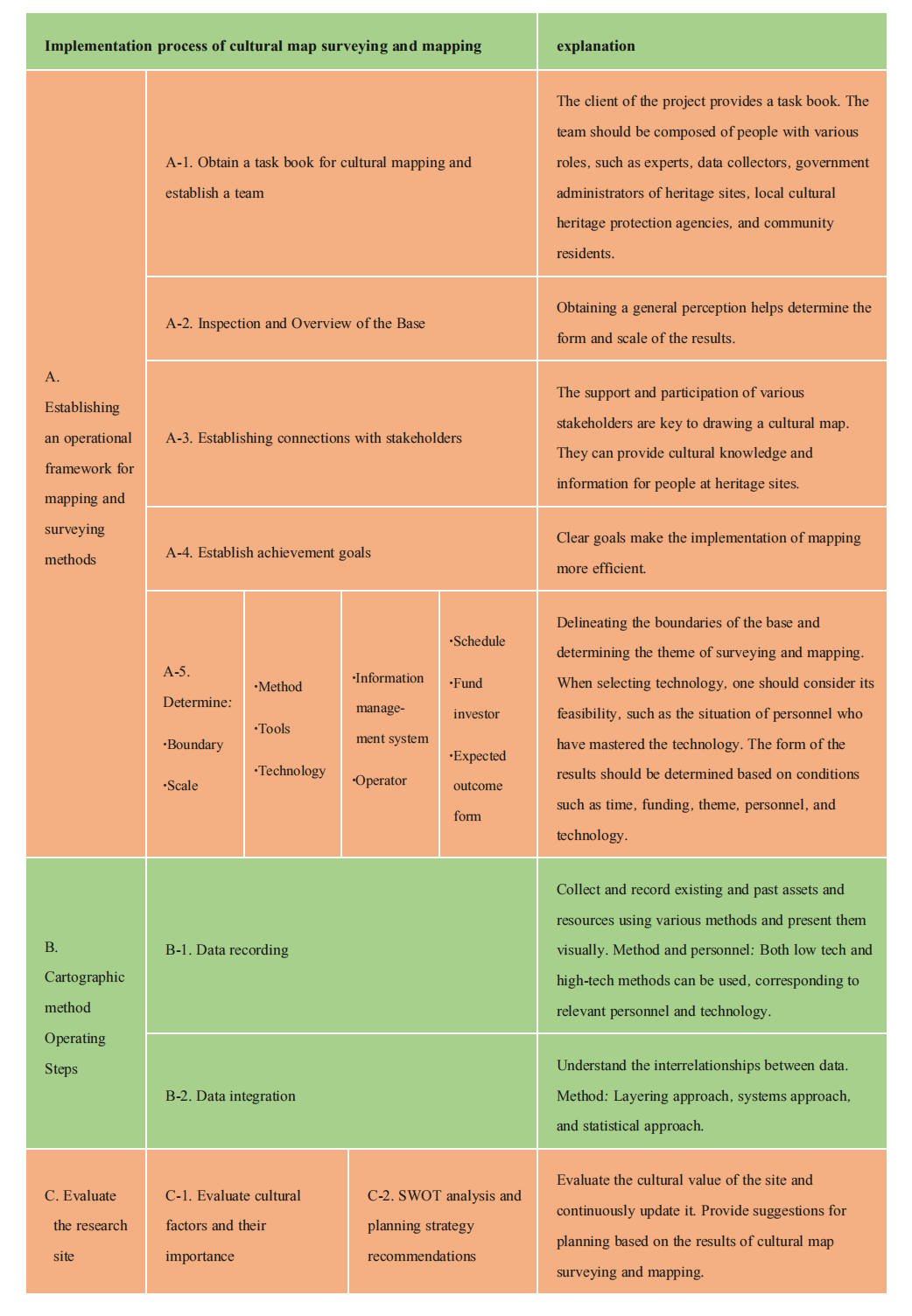
Mapping provides technical and methodological support for the production, interpretation, and dissemination of urban cultural maps, enabling the diverse cultures of cities to be more deeply understood by people through the visual tool of maps. In the process of creating urban cultural maps, mapping plays a certain role in every aspect: when establishing the operational framework of mapping and surveying methods, mapping is used to determine the form and scale of the results; when mapping, mapping is used to collect and record past and present asset and resource information, and the data are visualized and presented using layering approaches, systems approaches, and statistical approaches.
Understanding the interrelationships among data. In the process of evaluating and researching a site, mapping is used to evaluate the cultural value of the site and continuously update it. Based on this, urban cultural maps are drawn, and planning decisions are made based on them (Table 2).
Lates articles
Email: mspl@michelangelo-scholar.com
Tel: +852-66761250
WHATSAPP:+60 11-2370 2845
Room A, 3/F, Wing Tat Commercial Building, 121–125 Wing Lok Street, Sheung Wan, Hong Kong, China


JDSSI
MSPL
JACAC
DH
JAUD